publications
2026
-
 From extraction to recovery: Geomorphic and social transformations of gravel mining in the Lubhachorra River, Northeast BangladeshMd Sadiul Alam Chyon, Jim Best, and Shah Md Atiqul HaqCell Reports Sustainability
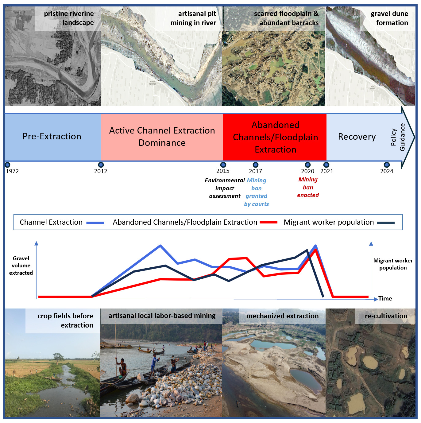
Gravel and sand mining is widespread globally, generating both societal benefits and detrimental impacts on physical landscapes and local livelihoods. This study examines the impacts of gravel mining on physical and human landscapes in Northeast Bangladesh, focusing on changes during mining and after its cessation. We adopt a mixed-methods approach, integrating remote sensing analysis with interviews of local residents. Four periods of mining were identified, revealing faster recovery of the active channel than of abandoned channels and the floodplain. Channel morphodynamic response shows extraction sometimes exceeding natural sediment supply, underscoring the need for sustainable practices. Interviews with residents and an environmental pressure group reveal contrasting views, with residents reporting post-mining hardships. We propose six policy recommendations for sustainable sediment extraction in Bangladesh and comparable sites: supporting artisanal and small-scale mining, rotational extraction zones with monitoring, empowering community involvement, prioritizing extraction outside the active channel, and restoring abandoned channels and floodplain areas.
2023
-
 Integrated assessment of flood risk in Arial Khan floodplain of Bangladesh under changing climate and socioeconomic conditionsMd Sadiul Alam Chyon, Subir Biswas, M. Shahjahan Mondal, Binata Roy, and Afeefa RahmanJournal of Flood Risk Management
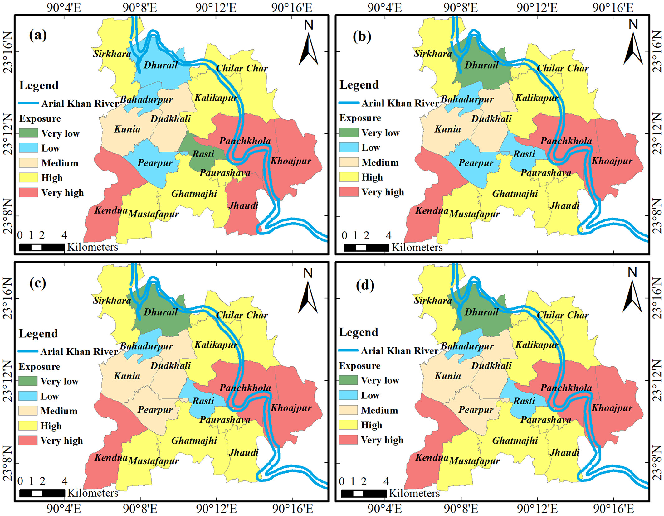
In the assessment of flood risk, the future flood hazard due to climate change is often tied to the present socioeconomic conditions. This makes an implicit assumption that the drivers of risk, other than the hazard, remain constant with time. Therefore, such risk assessment does not provide a realistic outlook for devising plausible mitigation strategies and plans. In this study, flood risk was assessed from an integrated perspective by considering both physical hazard, and socioeconomic exposure and vulnerability—all changing with time. The flood hazard in the Arial Khan River floodplain in the southcentral Bangladesh was simulated with a two-dimensional hydrodynamic model, and the exposure and vulnerability were projected using different statistical techniques. Principal component analysis was conducted to assign weights to the indicators of hazard, exposure, sensitivity, and adaptive capacity. The results show that the flood depth, duration, and extent would increase from the baseline to 2080s under regional concentration pathway (RCP) 2.6 and RCP 8.5 scenarios. The sensitivity and vulnerability would decrease, reflecting an improved adaptive capacity. The low-risk areas could increase from 62% in the baseline to 85%–91% in 2080s depending on the RCPs. The approach followed can be applied elsewhere in developing countries, particularly in riverine floodplain settings.
2017
-
 Comparative study on hydrodynamic performance of porous and non-porous submerged breakwaterMd Sadiul Alam Chyon, Afeefa Rahman, and Md Ataur RahmanProcedia Engineering
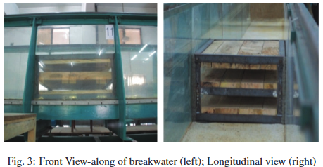
The paper offers a novel comparative case study on the performance of solid versus porous breakwater physically modeled under similar laboratory and wave conditions. Unidirectional waves were generated in a two dimensional laboratory flume having dimensions of 21.3 m length, 0.76 m width and 0.74 m height. Keeping still water depth of 50 cm, waves with T=1.6 sec, 1.7 sec, 1.8 sec and 2 sec were generated from a piston type wave generator. At 800 cm from the wave generator, horizontally slotted submerged breakwater of 100cm width,75cm length and 40 cm height were constructed with varying porosities of n=0.4, 0.5 and 0.6. Water level data were collected at six different locations for 12 unique run conditions. Using the measured data different hydrodynamic coefficients were calculated which include transmission co-efficient Kt, reflection co-efficient, Kr and wave energy loss co-efficient, KL. These co-efficient values were then, analyzed with respect to relative breakwater width (k.B), [where, k = wave number (2π/L), B = breakwater width] and porosity of breakwater. For the comparison, hydraulic performance of solid rectangular submerged breakwater of 40 cm height and 100 cm width was also reviewed which was modeled in the same laboratory under same wave condition of T=1.6,1.7 1.8 and 2.0 seconds and a still water depth of 50 cm. Experimental results from the porous breakwater and subsequent comparison of the results with solid breakwater indicate that, for transmitting less wave energy through the breakwater, maximum transmission co-efficient, Kt = 0.526 was obtained for porous breakwater with the lowest porosity (n=0.4) for T = 1.6 sec whereas for the solid breakwater maximum Kt= 0.5 was obtained for T=1.6 second. In terms of wave height, percentage wave height reduction was maximum 47% for porous breakwater whereas it was 68% for solid breakwater both at T=1.6 second. The hydrodynamic performance shows a significantly higher wave height reduction percentage for solid breakwater as anticipated by the physics of the interaction of the breakwater and the wave too. Besides, the position of wave breaking for different case scenario for both types of breakwater were recorded and analyzed which demonstrates that for porous breakwater waves tend to transmit through the slots and break at a certain distance beyond the breakwater whereas in case of solid breakwater, waves tend to break before or on the breakwater.
-
 Hydrodynamic and Morphological Impact of Hydraulic Structural Interventions: An Investigative Case Study on Feni-Muhuri River System of BangladeshMd Sadiul Alam Chyon, and Afeefa RahmanJournal of Water Resources and Pollution Studies
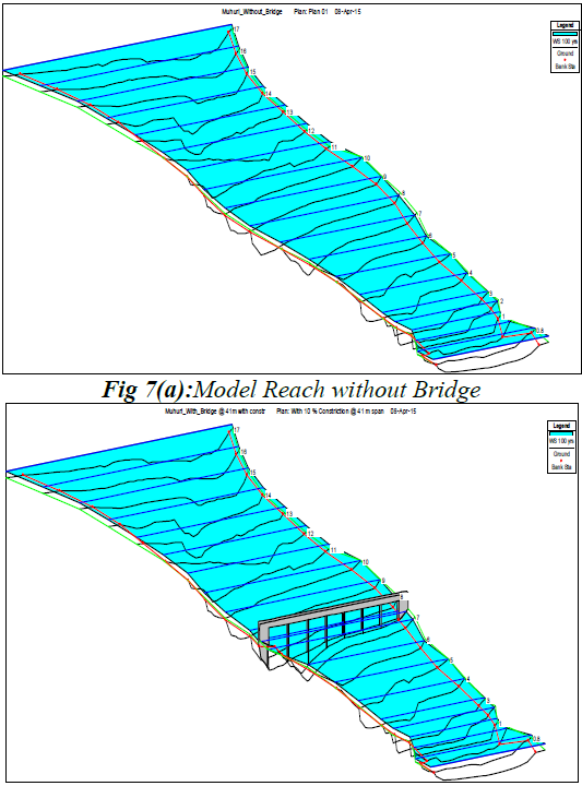
This paper offers an analysis on Muhuri River in terms of change in velocity, water level, scouring depth at different locations, thalweg shifting and afflux due to construction of structural intervention on Feni-Muhuri river system. Primarily, Gumbel’s distribution approach was adopted for fixation of the flood frequency analysis in terms of 25, 50 and 100 year return periods for both Feni and Muhuri River. Due to prevailing lunar dominancy, historical (1968-2009) tidal data had to be considered for estimating the design maximum and minimum water level at the available stations within the study reach. Discharge and water level data of different return periods were fed into the HEC-RAS 1D and 2D interface of Delft3D model as inputs of boundary conditions for the supplementary hydrodynamic and morphological investigation. Results on planform and thalweg analysis reveal significant siltation over the last decade in case of both the rivers. To analyze the hydraulic impact of bridge, a 1.65 km long reach was selected as the model domain. Velocity, variation in water surface elevation, scour depths have been studied for 5 different planning scenarios of the bridge and bankfull discharge condition in terms of variation in length and number of spans. General, Pier, Abutment, contraction, combined and local scour depths have been computed for the bridge using available approaches integrated in HEC-RAS.